
SCOPE OF WORK
Submarine Cable Survey
Lighthouse was engaged to perform a cable route survey for a new telecommunication submarine cable in the Atlantic Ocean between Faial, Flores, Corvo and Graciosa Islands (Azores Islands, Portugal).
The scope was to provide geological and bathymetric information to determine an optimal technically and economically viable route for the new cable.
DESKTOP STUDY
A Desktop study was performed at an early stage in cable route assessment in order to prepare a full description of the area interested by the route. The aim of this study was to provide pre-survey route position according to the route proposed by the Customer focusing the attention on several important factors:
- Environment: geology, submarine morphology, meteorology and oceanography, environmental impact;
- Human activities and related hazards: fishing, shipping, marine traffic, presence of wreck, coastal and marine natural reserves;
Preparation and Vessel Mobilization
The offshore survey was performed on board R/V Odin Finder whereas L/V Aguas Vivas was employed in the onshore part of the routes. Both of them were mobilized in Faial Island (Horta).
The vessels and the instruments needed to complete the work phases as per Scope of Work were set up according to our HSSE and Quality Standards.This ensures safe work place and conditions for our employees and as well as our subcontractors and client representatives.
Work Phases
The Cable Survey was performed according to the following steps:
- DTS site visits in Faial (Porto Pim bay), Flores (Boqueirão Port), Corvo Island (Boqueirão Port) and Graciosa Island (Carapacho)
- Desktop Study with propososal of different options of routes linking the islands
- Cable route corridor bathymetric and geophysical offshore and inshore surveys by means of MBES, SBES, SSS, SBP and magnetometer
- Data processing, final charting and reporting
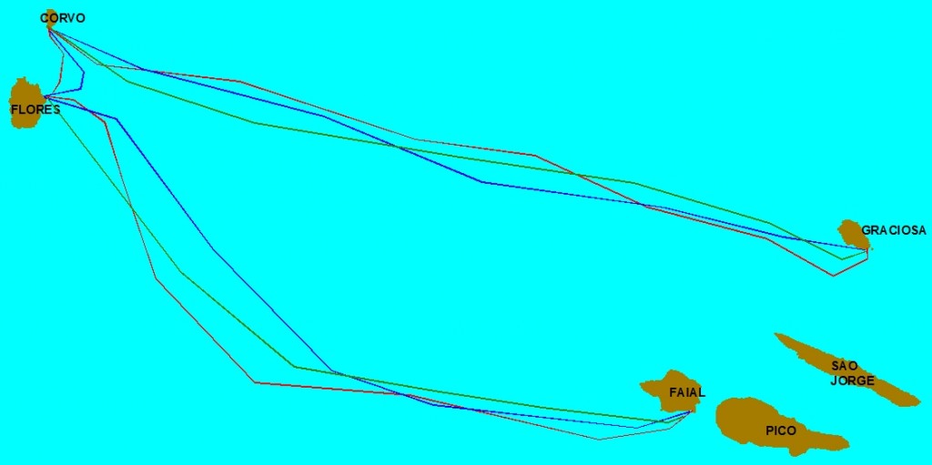
Different proposed route options
QUICK FACT
The project introduced for the first time the opportunity to enable the connection between all nine islands of the Archipelago of the Azores Islands. Approximately 630km were investigated.
METHODOLOGIES
Bathymetric and geophysical survey was performed in order to obtain the full coverage of the cable route corridor.
Data acquisition was finalised to define the seabed geology and bathymetry and the detection and mapping of seabed hazards related to natural or man-made activities. It was a challenging project due to the location close to the Middle Atlantic Ocean Ridge.
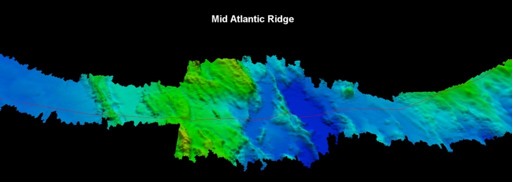
Mid Atlantic Ridge Southern Crossing
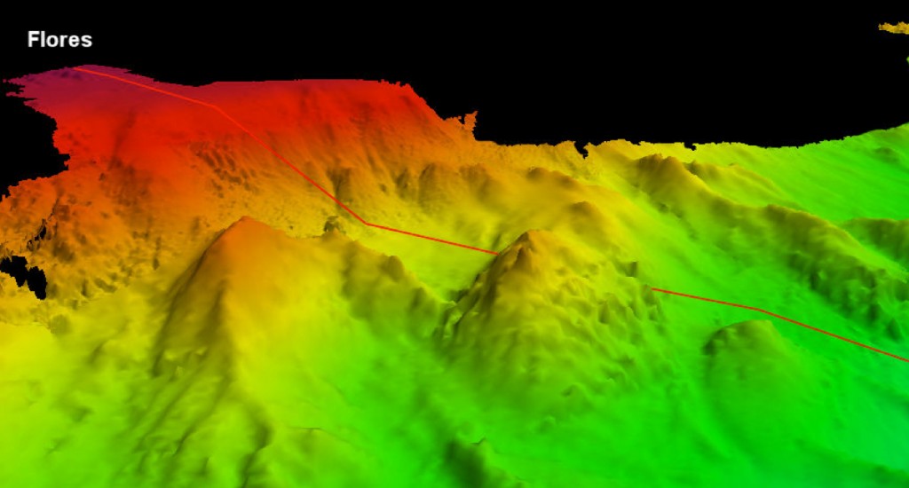
Flores’ Slope
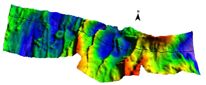
Northern Crossing of Mid Atlantic Ridge
Quality, Health, Safety and Environment
During the course of the project, Lighthouse implemented a series of measures to maintain a high level of safety onboard. Personnel respected the guidelines summarised in the HSSE, Emergency Response and Risk Assessment Plan. No violations were recorded. In general, every attempt was made to comply with the Company’s best practice.
Project Duration
Project lasted 6 months, from January to August 2013. This period includes each phase as desktop study (January to April 2013), mobilisation of the vessels (April 2013); survey and final data charting and reporting (April to August 2013).
The Vessel
R/V Odin Finder is 50 m long research vessel, owned by Lighthouse since 2001.
Equipment on board R/V Odin Finder
Primary Positioning System: DGPS C-Nav 3050M
Secondary Positioning System: DGPS C-Nav 1010R
Gyrocompass/Motion Reference Unit: GEM Polaris FOG-200
Gyrocompass/Motion Reference Unit: TeledyneTSS MAHRS
SVP Probe: Sea-Bird SBE19
Navigation Software: QPS QinSy v.8.10.2012.05.06.1
Bathymetric System: R2Sonic 2024
Bathymetric System:L3 Elac Nautik Seabeam 3030
Sub-bottom Profiler System: Teledyne Benthos Chirp III
Equipment on board L/V Aguas Vivas
Primary Positioning System: DGPS C-Nav 1010R
Secondary Positioning System: Hemisphere V100
Gyrocompass: Hemisphere V100
Motion Reference Unit: TSS MDS3-25
SVP Probe: Reson SVP15
Navigation Software: QPS QinSy v.8.10.2012.05.06.1
Bathymetric System: R2Sonic 2022
Side Scan Sonar: Klein 3900
Sub-bottom Profiler System: Innomar SES 2000 Compact
Magnetometer: Marine-Magnetics Sea-Spy
Bottom Sampling: Van Veen Grab